Eastern States 100
Waterville, Pennsylvania · August · 103 mi
- Distance
- 103.5 mi (167 km)
- One big loop
- Climbing
- 6,400 m (21,000 ft)
- Mountain: 38 m per km (203 ft per mi)
- Overall cutoff
- 36 hours
- 20:54 per mi (12:59 per km) average
- Finish rate
- 46%
- of starters in 2026
Why runners love it
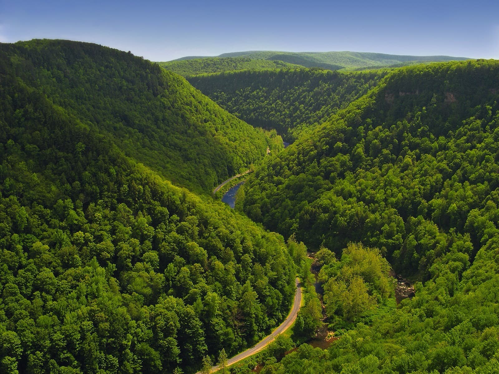
- Single loop of 103 mi (166 km) around Pine Creek Gorge, 98% single or double track
- About 6,400 m (21,000 ft) of climbing with steep rocky hollows and vistas
- Ham radio at every station and 200+ volunteers in a remote area
- Finish at the Little Pine State Park lake, with crowds cheering through the 17:00 limit
- $295 entry; pacers allowed from mile 43.6 (70 km)
Watch out for
- 36 h limit with latest-departure deadlines at ten stations; 46% finished in 2026
- Crew only at four stations; crew anywhere else means disqualification and a 3-year ban
- Rocky, slick footing, timber rattlesnakes, black bears and little cell service
- August heat near 34 C (93 F), with cancellations in 2018 and 2020
- A 50K-or-longer trail finish since January 2025 is required; drop bags at only five stations
Race
How runners feel about it, how well it is run, and the community around it. Counts for 25% of the overall score.
Toughness for its distance: Very tough
- Runner satisfactionLoved4.0
Few first-person reports were found; organizer and magazine coverage call it demanding but rewarding, with big finish-line crowds. · Low confidence
- OrganizationWell run4.1
Ham radio at every station, 200+ volunteers, live tracking and detailed rules and aid pages; the race was cancelled in 2018 and 2020. · Medium confidence
- Community and vibeWarm4.4
A nonprofit with club-captained aid stations and finish crowds that cheered every runner in the final hour in 2021. · Medium confidence
Support
Aid stations, crew access, drop bags and pacer rules. Counts for 25% of the overall score.
- Aid stationsGood3.5
14 stations plus a final checkpoint over 166.6 km (103.5 mi); the first is water-only and the longest gap is 15.8 km (9.8 mi). · High confidence
- Crew accessVery limited2.3
Crew is allowed only at AS3, AS7, AS10 and AS12 plus the finish; meeting a runner anywhere else risks disqualification. · High confidence
- Drop bagsSome stations2.9
Only five stations (AS3, 7, 10, 12 and 14) take drop bags, dropped off on Saturday morning. · High confidence
- PacersLate race3.3
Pacers may start at AS7 (mile 43.6, 70 km (43.5 mi)), AS10 or AS12, one at a time. · High confidence
Course
Course marking, scenery, and how runners rate the trail itself. Counts for 15% of the overall score.
- Course markingClear3.8
Pink flagging, reflective markers and signs, but the race warns some turns are easy to miss; steel gates near mile 45 (72 km). · Medium confidence
- SceneryBeautiful4.4
Pine Creek Gorge vistas, laurel and blueberry, and a lakeside finish. · Medium confidence
- Trail experienceGreat3.8
Rugged, rocky, steep single-track with long runnable plateau stretches between the hollows. · Medium confidence
Course traits, not part of the score
- FootingTechnical1.5
Rocky hollows, moss-covered stones, outcrops and a rock scramble near the finish; reports call it Rocksylvania. · High confidence
- RunnabilityLots of hiking2.2
Steep technical climbs and descents, with long runnable stretches on the plateau. · Medium confidence
- ClimbingHilly1.9
Climbs 203 ft per mi (38 m per km), from the official elevation gain. · High confidence
Conditions
Race-day temperature and how predictable the weather is. Counts for 14% of the overall score.
- Race-day temperatureHarsh2.4
August heat and humidity, around 34 C (93 F) on exposed trail, and slick rocks in humid mornings. · Medium confidence
- Weather reliabilityUnsettled2.4
Thunderstorms and a microburst in past editions, and cancellations in 2018 and 2020. · Low confidence
Course traits, not part of the score
- AltitudeLow4.4
The race gives no high point; the course is in the Pennsylvania Wilds. · Low confidence
Cutoffs
How generous the overall and intermediate cutoffs are for the terrain. Counts for 13% of the overall score.
- Overall cutoffNormal3.0
36 h for 166.6 km (103.5 mi) with about 6,400 m (21,000 ft) of climb, about 21 min per mile; 46% finished in 2026. · High confidence
- Intermediate cutoffsReasonable2.8
Latest-departure deadlines at ten stations, from 6:30 elapsed at AS3 to 34:45 at mile 99.7 (160 km); about 19 to 21 min per mile. · High confidence
Intermediate cutoffs (2027 race info and rules pages, 2026 results, 2025 aid station table)
| Where | Distance | Cutoff |
|---|---|---|
| AS3 Lower Pine Bottom, mile 18.2 (latest departure) | 29 km (18 mi) | 11:30 Saturday (6:30 elapsed) |
| AS5 Happy Dutchman, mile 32.0 (latest departure) | 52 km (32 mi) | 16:30 Saturday (11:30 elapsed) |
| AS7 Hyner Run, mile 43.6 (latest departure) | 70 km (44 mi) | 20:15 Saturday (15:15 elapsed) |
| AS9 Big Trail, mile 57.0 (latest departure) | 92 km (57 mi) | 00:45 Sunday (19:45 elapsed) |
| AS10 Tomb Flats, mile 63.3 (latest departure) | 102 km (63 mi) | 03:00 Sunday (22:00 elapsed) |
| AS11 Cedar Run, mile 73.1 (latest departure) | 118 km (73 mi) | 06:30 Sunday (25:30 elapsed) |
| AS12 Blackwell, mile 80.9 (latest departure) | 130 km (81 mi) | 09:15 Sunday (28:15 elapsed) |
| AS13 Sky Top, mile 85.4 (latest departure) | 137 km (85 mi) | 10:45 Sunday (29:45 elapsed) |
| AS14 Barrens, mile 93.5 (latest departure) | 151 km (94 mi) | 13:30 Sunday (32:30 elapsed) |
| Checkpoint Hackett, mile 99.7 (latest departure) | 161 km (100 mi) | 15:45 Sunday (34:45 elapsed) |
Not part of the score
- First timer friendlyDemanding1.6
Organizers say it is not for beginners, and about 49% of starters finish. · High confidence
- Getting inSells out3.2
Open sign-up for 300 places, but a 50K or longer trail finish since 2025 is required; fill speed is not stated. · Low confidence
Stay and travel
Getting there, places to stay, race-day logistics and value. Counts for 8% of the overall score.
- Travel easeAwkward2.3
Remote Pennsylvania Wilds with little cell service; the race does not name an airport. · Low confidence
- Places to stayBook early3.0
Little Pine State Park is on the course and the race site lists area lodging, which was not checked. · Low confidence
- LogisticsSome complexity3.2
One start and finish at Little Pine and a single loop, but strict crew points and remote stations. · Medium confidence
- ValueGood value3.8
$295 for a staffed 166 km (103 mi) event with 200+ volunteers is modest. · Medium confidence
Key facts
Checked against the 2027 race info and rules pages, 2026 results, 2025 aid station table edition on the official race site. Rules change, so confirm before you enter. Blank means the race does not publish it.
- Location
- Waterville, Pennsylvania, United States
- Region
- Northeast US
- Typical month
- August
- Latest or next date
- 14 August 2027
- Start time
- 05:00
- First held
- 2014
- Distance
- 103.5 mi (167 km)
- Course shape
- One big loop
- Surface
- Trail: About 98% single or double track (race info). Mid State Trail, Black Forest Trail and West Rim Trail, plus logging grades, gravel, ATV, powerline and pipeline sections and a stretch of the Pine Creek Rail Trail.
- Footing
- Official course narrative: about 21,000 ft (6,400 m) of climb and a similar amount of descent when the 2026 chart's section figures are summed; the race info page says over 20,000 ft (6,100 m). Steep, rocky hollows are a signature feature, with moss-covered stones, outcrops and slippery footing. The course page warns of timber rattlesnakes and black bears. The race info page says 103 mi (166 km), the 2026 chart totals 103.5 mi (166.6 km), and the narrative's own segments add to more; no high point is published.
- Elevation gain
- 6,400 m (21,000 ft)
- Climbing rate
- 38 m per km (203 ft per mi)
- Overall cutoff
- 36 hours
- Pace to make the cutoff
- 20:54 per mi (12:59 per km)
- Cutoff notes
- Finish by 17:00 Sunday, 36 h after the 05:00 Saturday start. The 2026 official aid station chart lists a latest departure time at each of these stations; if you are not out by then your race ends. Miles are the chart's cumulative distances.
- Aid stations
- 15
- Longest gap between aid
- 16 km (9.8 mi)
- Drop bags
- Some stations
- Crew access
- Some points
- Pacers
- Allowed from AS7 Hyner Run (mile 43.6 / 70 km), one pacer at a time
- Support notes
- The 2026 official chart lists AS1 to AS14 plus Checkpoint Hackett (mile 99.7). AS1 Ramsey Road is water only. The largest gap is AS10 Tomb Flats to AS11 Cedar Run, 9.8 mi (15.8 km), taken from the chart's section distances. Crew is allowed only at AS3, AS7, AS10 and AS12 plus the start and finish; meeting a runner anywhere else brings disqualification and a three-year ban. Drop bags go to AS3, AS7, AS10, AS12 and AS14. Pacers may start at AS7, AS10 or AS12.
- Water crossings
- Many
- Water notes
- Frequent stream crossings (Dam Run, Ramsey Run, Browns Run, Hackett Fork and several of Pine Creek); the Tomb Flats Pine Creek crossing is a deliberate wet-feet moment.
- Night running
- Most runners run through one night
- Mandatory gear
- Headlamp before daybreak and after dark; emergency blanket. GPX of the course strongly recommended.
- Entry
- Qualifier
- Qualifier needed
- Finish of an advertised 50K trail race or longer within its cutoff, from January 1, 2025, with public results. Timed events, FKTs, OCR and most multisport events do not count.
- Entry fee
- About $295
- Field size
- About 300 runners
- Finish rate
- 46% of starters in 2026
- Weather notes
- Thunderstorms have hit the race, including a storm near 3 am at Blackwell in 2014 and a microburst the day before the 2021 race. Little to no cell service on much of the course.
- Stay notes
- Start and finish at Little Pine State Park, in the Pennsylvania Wilds; the race site has an area page and eat and do list. Airport not stated.
- Course record (men)
- 18:23:47 (as of the 2021 organizer post)
Races like this
See every race ranked by likenessClosest on distance, course shape, climbing, footing, region and season.

Fort Valley (Caroline Furnace Camp, near Woodstock), VA
Also 100 mi · Point to point or one big loop · Similar climbing
Mount Solon, VA
Also 100 mi · Similar climbing · Similar footing
West Windsor, VT
Also 100 mi · Point to point or one big loop · Also in the Eastern US
Two Harbors (start) to Lutsen (finish), MN
Also 100 mi · Point to point or one big loop · Similar footing
What runners and reviewers say
- Rush of It All, Jeff Calvert (2021 recap)Raced 2021 · blog · Mixed
Recap by the logistics coordinator. 103.1 mi (166 km) with over 20,000 ft (6,100 m) of climbing, rocky and rooty trail made slick by morning humidity. 83 of 162 starters finished and many back-of-pack runners came in during the last hour of the 36 h limit.
- Rush of It All, Jeff Calvert (preview)Raced 2021 · blog · Positive
Organizer's preview: a 103.1 mi (166 km) clockwise loop around Pine Creek Gorge, over 95 mi (153 km) of single or double track, 16 stations, ham radios, 200+ volunteers. Stresses storms in 2014 and heat near 93 F (34 C).
“smile through the darkest moments”
- MassUltra roundup (2016)Raced 2016 · article · Mixed
Describes it as gorgeous and grueling with about 19,000 ft (5,800 m) of vertical in 102.9 mi (165.6 km). Only 66 of 196 starters finished inside the 36 h limit in the third year.
- Trail Sisters (listing)Raced 2026 · aggregator · Positive
Listing as Trail Sisters Approved: a 103 mi (166 km) loop on the Mid State and Black Forest trails, about 98% single or double track, over 20,000 ft (6,100 m) of gain, remote and technical, with August heat and humidity. No runner reviews.
- Ultra Running Magazine calendar (listing)Raced 2025 · aggregator · Mixed
Search snippets, not the full page (page blocked). 133 finishers in 2025, 131 in 2023, a 'Massanutten on steroids' comparison from 2017 and a cutoff complaint dating to 2014; cancelled in 2018 and 2020.
Ran Eastern States 100? Your notes on the footing, cutoffs and aid stations help the next runner decide.
Sources
Pages we used for facts and ratings.
Training for Eastern States 100? Moku Coach builds your plan around race day.